Written by George Mourkousis on 14 March 2025.
Posted in Article.
Keywords: Scientific Analysis | Border Management Innovation | European Research
Recent research reveals a fundamental shift in how border surveillance systems are designed and implemented. Rather than starting with technology, successful projects begin with the people who will use these systems every day.
The Human Element in High-Tech Security
For decades, border security technology development followed a predictable pattern: engineers created sophisticated systems and expected border guards to adapt. The results were often expensive failures—technology that worked perfectly in laboratories but failed in real-world conditions.
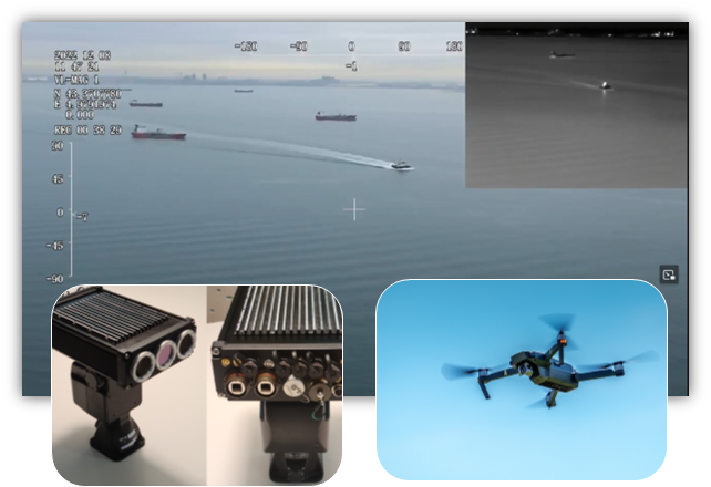
Recent research from Finland’s VTT Technical Research Centre demonstrates why this approach was fundamentally flawed. Their work on maritime border surveillance reveals that the most advanced technology becomes useless if it doesn’t align with human operational needs.
Key Insight: The most sophisticated border surveillance system is only effective when border guards can actually use it effectively in high-pressure situations.
Participatory Design: A Game-Changing Approach
The European research introduces “participatory design”—a methodology that flips traditional development on its head. Instead of technology driving the process, real users drive the requirements from day one.
This approach recognizes that maritime border security involves complex coordination between numerous agencies: border guards, coast guards, customs officials, fisheries control, and environmental protection services. Each has unique needs and operational constraints.
How It Works in Practice
The research demonstrates that participatory design involves continuous dialogue between developers and end-users throughout the development process. Border guards don’t just test finished products—they help shape every aspect of the system from initial concepts to final implementation.
This iterative process ensures that technological capabilities align with operational realities. For example, a surveillance system might have perfect technical specifications, but if it requires complex procedures that slow down emergency responses, it fails the ultimate test of operational effectiveness.
Real-World Impact and Benefits
The European studies reveal several transformative benefits of this human-centered approach:
Documented Advantages
- Enhanced Technology Acceptance: When users help design systems, they’re more likely to embrace and effectively use the technology
- Reduced Development Risk: Early user feedback prevents costly late-stage redesigns
- Improved Operational Fit: Systems align with actual workflows rather than theoretical processes
- Faster Implementation: Reduced training time and smoother adoption curves
The research shows that this approach is particularly critical in security domains where split-second decisions have life-or-death consequences. Border guards operating in challenging maritime environments need technology that enhances their capabilities without adding cognitive burden.
Scientific Innovation and Methodology
The breakthrough in this research lies not just in the outcomes, but in the rigorous scientific methodology developed. The researchers created systematic frameworks for capturing and integrating user requirements across diverse stakeholder groups.
This represents a significant advancement over traditional requirements gathering, which often relies on static documentation and limited user consultation. The participatory approach creates dynamic feedback loops that continuously refine system design.
Scientific Contribution: The research provides replicable methodologies for complex, multi-stakeholder technology development in high-stakes environments.
Implications for Future Border Technology
The implications extend far beyond maritime surveillance. The methodologies developed in this research provide a template for any complex security technology development involving multiple stakeholders and high-stakes operations.
As border security challenges become increasingly complex—involving irregular migration, transnational crime, and environmental protection—the need for well-designed, user-centered technology becomes more critical. This research provides the scientific foundation for meeting that challenge.
The European experience demonstrates that successful border security technology isn’t just about technical capabilities—it’s about creating systems that work for the people who depend on them every day.
Looking Forward
The research from European border security experts represents a paradigm shift in how we approach technology development for critical security applications. By putting human needs at the center of the design process, we can create systems that are not only technologically advanced but also operationally effective.
This human-centered approach offers a path forward for developing border security technology that actually works in the real world—technology that enhances rather than complicates the critical work of protecting our borders.
*This analysis is based on peer-reviewed research from European border security experts and represents current scientific understanding in the field.